- Un cortometraje reciente, Pygmy Peoples of the DRC: A Rising Movement (Los Pueblos Pigmeos de la RDC: Un Movimiento Creciente), sigue la lucha por el reconocimiento de los derechos sobre tierras indígenas en la RDC.
- La película cataloga la importancia de la selva para los grupos indígenas, así como su papel como guardianes de la selva.
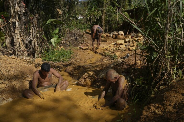
La palabra “pigmeo” conjura imágenes de cazadores-recolectores que viven en las profundidades de la selva tropical del Congo, muy alejados del mundo moderno. Pero ese mundo moderno está cada vez más cerca de ellos, al ir cayendo las selvas en las que viven para proporcionar madera al resto del mundo y abrir paso a las inmensas granjas industriales.
Ahora, los pigmeos de la República Democrática del Congo se están uniendo para demostrar tanto el valor de la selva para su sociedad como su papel de guardianes de este recurso.
“Es el lugar de espíritus, invocaciones, conjuros y reencarnación”, dice Marie Lisenga en un cortometraje reciente, Pygmy Peoples of the DRC: A Rising Movement (Los Pueblos Pigmeos de la RC: Un Movimiento Creciente). “Es nuestro hogar”.
El documental es parte del proyecto Si no somos nosotros, ¿quién entonces? con la misión de exponer cómo las comunidades son fundamentales para proteger las selvas y afrontar temas como el cambio climático. Como muchos grupos indígenas por todo el mundo, los pigmeos de la RDC están luchando por conservar las tierras que han cuidado durante generaciones.
“No se reconoce nada indígena”, dice Kapupu Diwa Mutimanwa, líder del grupo étnico Twa y presidente de la Liga de Asociaciones Pigmeas Indígenas del Congo, conocida por sus siglas en francés LINAPYCO. “Hay leyes consuetudinarias indígenas, pero nadie las reconoce. Así que debemos cambiar esto”.
La manera en que los pigmeos dicen que son tratados reviven las creencias racistas de la época colonial sobre quiénes son.
Lee más | Tierra abrasada: los “agricultores refugiados” de Colombia vuelven a sus territorios
“Somos considerados ‘infrahumanos’ como una raza inferior, personas que ni siquiera pueden pensar”, dice Joseph Itongwa Mukumo, miembro del grupo Walikale en la provincia Kivu del Norte de la RDC y coordinador de la REPALEF, la Red de Pueblos Indígenas y Comunidades Locales para la Gestión Sostenible de los Ecosistemas Forestales.
De hecho, un creciente número de investigaciones han demostrado que los grupos indígenas son unos protectores extremadamente eficaces de las selvas que siguen en pie, en muchos casos, mejor que las zonas protegidas tradicionales como los parques y las reservas.
Mientras Lisenga señala plantas medicinales y comestibles durante la película, explica como su gente dependiente de la selva hace un uso sostenible de la tierra.
“No talamos los árboles”, dice Lisenga. “Protegemos la selva, solo cogemos lo que cae”.

La comunidad internacional está despertando ante el papel fundamental de los pigmeos en la protección de las selvas en la RDC. Ahora, los grupos dirigidos por Itongwa y Diwa luchan por la protección legal de las tierras de los pigmeos en forma de reforma de la tenencia de las tierras, porque, como ellos lo ven, estos grupos indígenas proveen un servicio no solo a la RDC, sino a todo el mundo.
“El conocimiento indígena tradicional es reconocido como eficiente para abordar las situaciones del cambio climático”. Dice Itongwa. “Estamos orgullosos porque construimos y protegemos lo que es importante para la humanidad”.
Imagen de cabecera de mujeres Batwa de Doublearc [CC0], vía Wikimedia Commons.
Sigue a John Cannon en Twitter: @johnccannon
COMENTARIOS: Usa este formulario para enviar un mensaje al autor de este artículo. Si quieres agregar un comentario público, lo puedes hacer en la parte inferior de esta página.


